COSMICS · CHAPTER 6.2
The Ground Is Not a Surface
Roots, groundwater and buried processes begin where most remote sensing becomes inference.
EARTHVISION LAB · ~15 MIN READ
THE SUBSURFACE
A satellite can map a continent while being almost completely unable to see what is happening one metre below it. That is not a resolution problem. It is a physics problem. Most electromagnetic signals used for Earth observation interact with the surface, vegetation or the shallowest part of the ground long before they reach the roots, aquifers, buried pipes and geological layers that determine what happens above.
The word ground encourages a useful misunderstanding. It sounds like a boundary. In hydrology, agriculture and geology it is closer to the top of a volume. Water moves downward through soil, roots extract it, groundwater rises and falls, pore pressure changes, sediments compact, heat diffuses and chemistry evolves. The surface records some consequences. It does not expose the full state.
This is why subsurface monitoring is usually a coalition of methods rather than one observing system. Wells measure water levels at points. Soil probes measure tiny volumes. Geophysical instruments respond to bulk properties. Satellites observe surface moisture, deformation or gravity. Models connect these fragments into a state that no single instrument can see directly.
ROOT-ZONE MOISTURE
SMAP sees five centimetres and models the next metre
NASA's Soil Moisture Active Passive mission makes the boundary unusually explicit. Its L-band radiometer is sensitive to moisture in roughly the upper 0 to 5 centimetres of soil. That thin layer matters because it exchanges water and energy with the atmosphere, but crop roots and vegetation often depend on moisture far deeper than the microwave observation directly reaches.
NASA's Level-4 soil-moisture product therefore estimates the root zone, defined in the product as roughly 0 to 100 centimetres. It does this by assimilating the satellite brightness-temperature observations into a land-surface model that represents water moving between surface and deeper reservoirs. The current product is global at 9-kilometre resolution and updates every three hours.
The distinction between measurement and estimate is not a criticism. It is the entire design. The observation constrains the surface. Rainfall forcing and physical relationships move information vertically and through time. The model supplies continuity where the instrument cannot directly look. Root-zone moisture becomes knowable because several pieces of evidence agree enough to support an estimate.
This is a recurring pattern in Earth systems. A product name may say root-zone soil moisture, but the satellite did not send a signal down one metre and receive the water content back. The deeper state is a model-informed inference. The file can be scientifically excellent and still represent a different epistemic object from a direct observation.
AQUIFERS
Groundwater is observed through holes, weight and movement
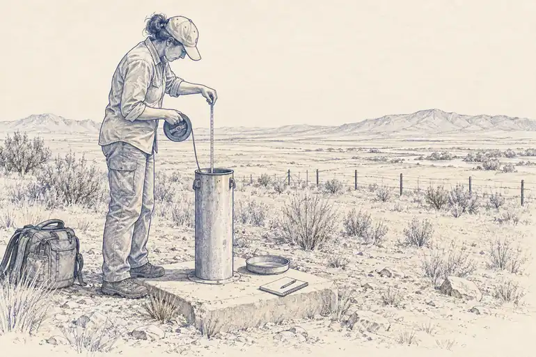
Groundwater is harder because the relevant reservoir can extend hundreds of metres below the surface and because pumping occurs through millions of wells whose withdrawals are not always measured continuously. The most literal observation is still a monitoring well. Lower an instrument into the aquifer and measure the water level. The measurement is direct and local, which is both its strength and its inconvenience.
A regional aquifer cannot be represented by one well any more than an atmosphere can be represented by one thermometer. Hydrogeologists therefore combine networks of wells with geology, pumping records, precipitation, streamflow and models. Where sediments compact as water pressure falls, the land surface itself can become an indirect instrument.
Interferometric synthetic aperture radar, or InSAR, measures tiny changes in surface elevation by comparing the phase of radar observations acquired at different times. In groundwater basins, persistent subsidence can reveal aquifer-system compaction associated with extraction. USGS uses InSAR alongside wells, GPS and borehole extensometers because each observes a different part of the process.
The surface deformation is not groundwater volume. The relationship depends on sediment properties, aquifer mechanics and whether deformation is elastic or permanent. A sinking surface is evidence about what happened below, not a transparent window into it. The ground has politely supplied a symptom.
BIOLOGY BELOW GROUND
The root system is a hidden machine
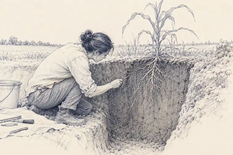
Agriculture makes the missing volume practical. Two fields with similar canopy colour can have very different root depth, soil structure, salinity and access to groundwater. Those differences change how long a crop can survive heat or a failed rain event. The plant above ground is partly a readout of machinery below ground that satellites rarely observe directly.
Roots are measured with methods that make global coverage unlikely: soil cores, excavations, minirhizotron cameras placed in transparent tubes, electrical and radar methods, isotope tracing and models. Each sees a fragment. Even root biomass is difficult because fine roots turn over quickly and are distributed unevenly through soil.
This matters for carbon as well as water. A substantial portion of plant carbon enters soil through roots, exudates and associated microbial processes. Surface greenness can therefore change less than the below-ground carbon balance. An observing system optimized for leaves is looking at the part of the plant that happens to face space.
The same geometry applies to buried infrastructure, permafrost, contamination and geological storage. Surface observations can detect deformation, temperature anomalies or vegetation responses. The hidden process often has to be inferred through a chain of consequences.
THE OBSERVABILITY GAP
A map of the surface is not a map of the land
Land systems are routinely represented as layers: soil moisture, groundwater stress, root-zone water, carbon stock, subsidence. The representation is convenient because every layer can be aligned to the same map. The underlying observations are not aligned nearly so neatly. One may come from a satellite skin-depth measurement, another from wells, another from surface deformation and another from a model.
This is where observability becomes more useful than resolution. A variable can be mapped at 10 metres and still be weakly observed if the value is inferred from a proxy. Another can be measured directly at one borehole and be highly observed there while completely unknown fifty kilometres away. Spatial detail and evidential strength are different axes.
A planetary intelligence that treats them as the same kind of layer will inherit a quiet error. It will know where every value is located but not how far the value sits from a real measurement. The subsurface makes that distinction impossible to ignore.
The ground is not where observation ends. It is where direct observation becomes expensive enough that inference starts looking like a surface.