COSMICS · NOTE 002.7
Sentinel and the Public Infrastructure of Observation
A manifesto signed in a small Italian town in 1998 became Europe's answer to depending on someone else's satellites.
EARTHVISION LAB · ~14 MIN READ
THE INDEPENDENT PATH
On 19 May 1998, in the small Italian town of Baveno, representatives of the European Commission, Europe's space agencies, and EUMETSAT signed a document proposing a long-term European Earth monitoring program. They called it Global Monitoring for Environment and Security, GMES. It would take until 2012 for the program to be renamed Copernicus, and years more before most of its satellites reached orbit, but the underlying decision was made in Baveno: Europe would not depend indefinitely on another government's satellites for infrastructure-grade Earth observation.
STRATEGIC REASONING
Access to data is not the same as control over it
Landsat's data has been freely usable by anyone since 2008, Europe included. That was never really the concern. The concern, latent since Baveno and sharpened by Landsat's own 1989 near-shutdown under a failed privatization experiment, was that Europe had no say in whether Landsat kept flying, what it measured, or how long its archive stayed funded, decisions made entirely inside one other country's budget process.
GMES became an ESA-EU joint framework in 2004, one milestone in a program that had already been under discussion for six years, and adopted a data policy that goes further than Landsat's: full, free, and open, formalized through an EU delegated act, meaning not just free to download but explicitly unrestricted for commercial reuse from the outset.
This was a political commitment dressed as a technical program, made more than two decades before it would be tested. Building redundant infrastructure a nation does not strictly need yet, in case dependence on someone else's ever becomes a liability, is a decision governments rarely make this far ahead of the failure they are hedging against.
SENTINEL-1
Radar filled the one gap Landsat never closed
Landsat and its successors have always been optical instruments, dependent on sunlight and clear sky. Sentinel-1, first launched in 2014, carries a C-band synthetic aperture radar instead, resolving to about 5 meters in its sharpest mode and covering swaths up to 400 kilometers in its widest, regardless of cloud cover or time of day.
No version of Landsat has ever carried radar. Sentinel-1 does not compete with Landsat's archive so much as complete it, closing a gap that becomes acute in the tropics, where cloud cover can obscure the ground for weeks at a stretch.

SENTINEL-2
Two satellites, phased apart, beat Landsat's revisit outright
Sentinel-2 flies identical satellites in the same orbital plane, phased 180 degrees apart, at 786 kilometers altitude with a 290-kilometer swath, cutting the revisit any single satellite in that orbit would manage, 10 days, down to 5. Its imager also carries 13 spectral bands against Landsat's smaller set, with its sharpest bands resolving to 10 meters against Landsat's 30.
This does not make Landsat obsolete. It makes Sentinel-2 a second, independently controlled measurement of much of the same ground, which was the entire point of building it.
THE REST OF THE FAMILY
Sentinel was never meant to be two satellites
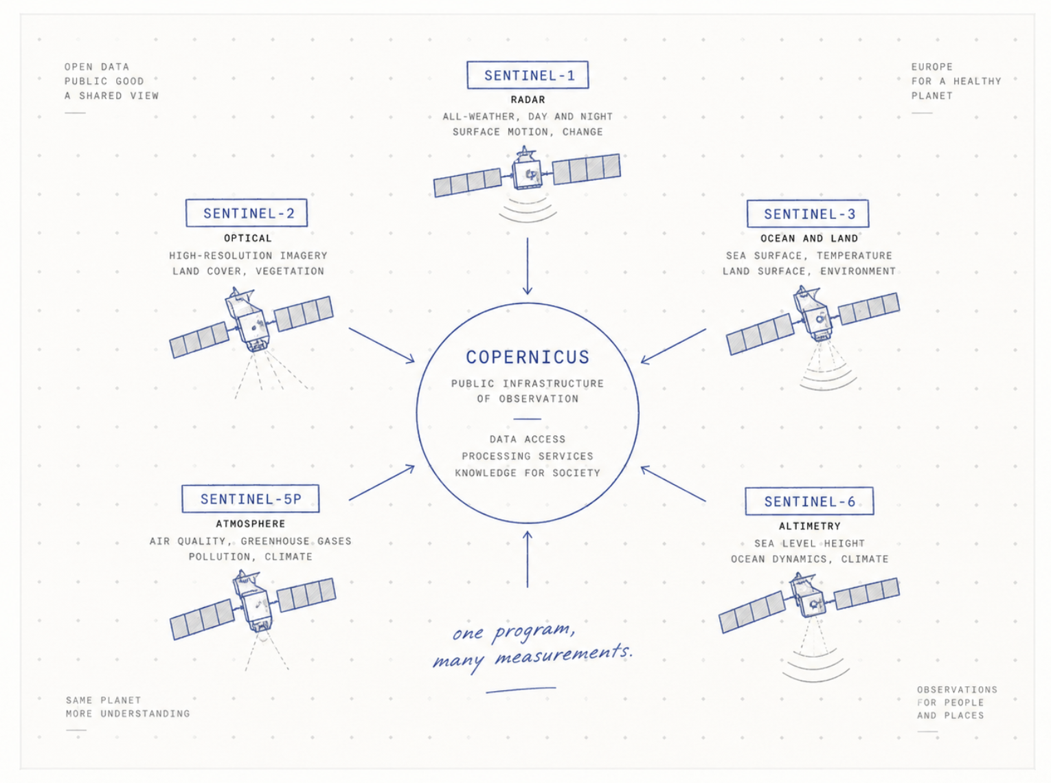
Public discussion of Copernicus tends to stop at Sentinel-1 and Sentinel-2, the two missions that most resemble Landsat. The program is built around at least four more, each closing a gap the other two do not touch. Sentinel-3 carries an ocean and land color instrument alongside a sea and land surface temperature radiometer, plus a radar altimeter, measuring ocean topography and ice sheet elevation in the way Landsat's optics never could.
Sentinel-5P carries TROPOMI, an instrument built to measure atmospheric trace gases: nitrogen dioxide, methane, sulfur dioxide, ozone, at a spatial detail no previous atmospheric chemistry satellite had managed, launched specifically to track pollution sources down to individual power plants and cities. Sentinel-6 carries a radar altimeter dedicated to sea level, continuing a measurement record that other satellites, under other names, had been keeping since the early 1990s.
Each flies its own orbit, carries its own instrument, and answers a question Sentinel-1 and Sentinel-2 do not. That is deliberate. Copernicus was never designed as a Landsat competitor. It was designed as a complete measurement system, land, ocean, atmosphere, and ice, of which land imaging is only one quarter.
THE WORLDWIDE CONSEQUENCE
A second archive changed what counts as normal
Copernicus data now underpins emergency response systems, climate monitoring programs, and research groups worldwide, many in countries that could never have afforded commercial-grade imagery and would otherwise have relied on Landsat alone.
Two governments now separately fund the same kind of commitment across land, ocean, and atmosphere. That is not efficient in the narrow sense. It duplicates hardware, ground stations, and processing pipelines. It is exactly the inefficiency Europe decided, in Baveno in 1998, it was willing to pay for.