COSMICS · NOTE 002.2
The Orbits That Shaped Modern Observation
Altitude alone explains almost nothing. Five orbital families explain almost everything.
EARTHVISION LAB · ~15 MIN READ
ORBITAL MECHANICS
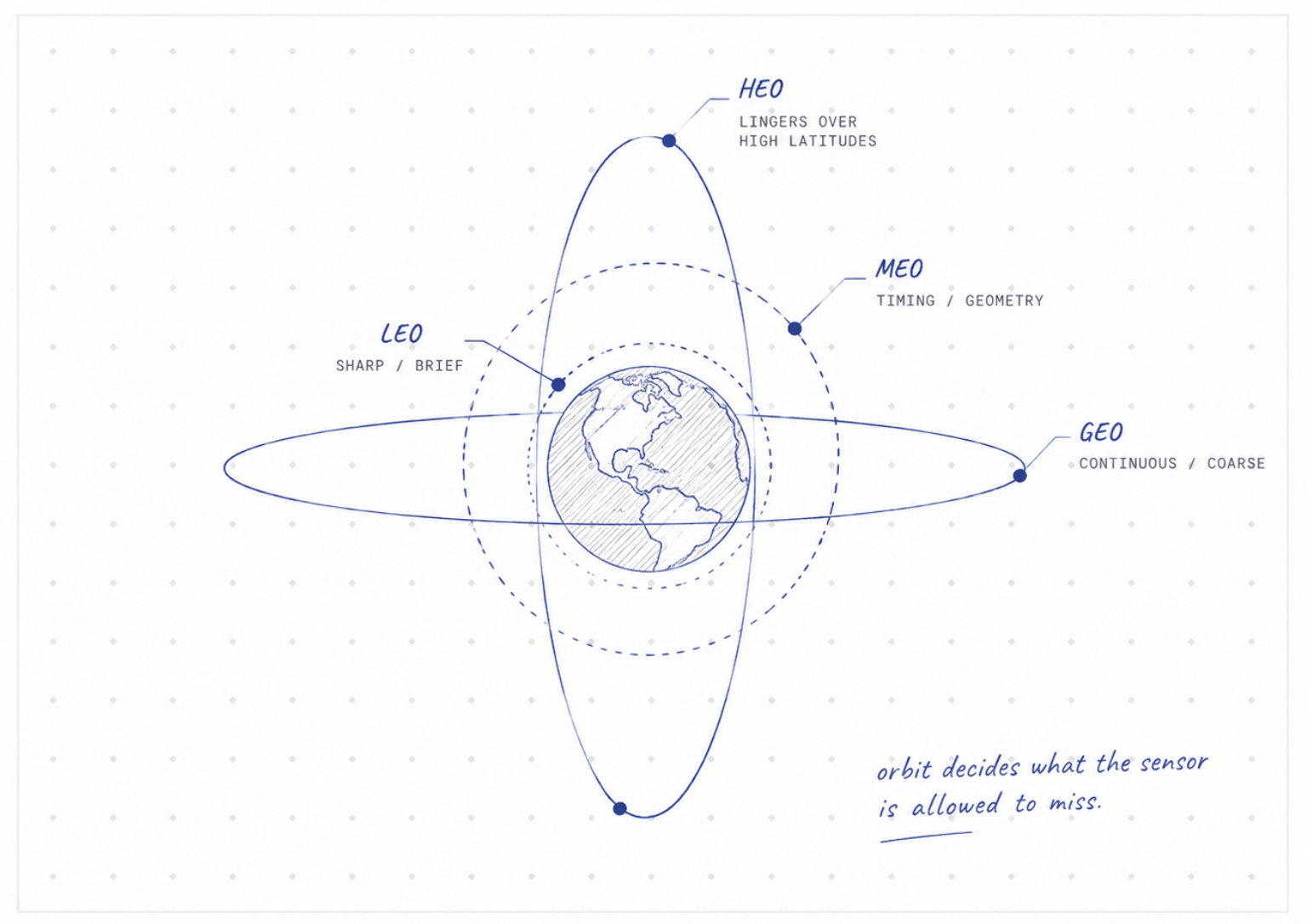
A satellite's orbit is not a design flourish. It is a constraint that decides what the satellite can see, how often it sees the same ground again, and what the light looks like when it does. Before a mission chooses a sensor, its orbit has already decided what that sensor is allowed to miss.
LOW EARTH ORBIT
Low orbit trades coverage for detail
Low Earth orbit, LEO, spans roughly 200 to 2,000 kilometers up. Landsat 8 and 9 fly at 705 kilometers, low enough to resolve 30-meter pixels but too low to see more than a narrow 185-kilometer strip at once. The satellite returns to the same strip of ground every 16 days.
That number has changed once already. Landsat 1 through 3 flew a slightly different orbit with an 18-day repeat cycle, tightened to 16 days when Landsat 4 launched in 1982. The gap is not a limitation nobody fixed. Photographing 30-meter detail across the whole planet without seams requires letting the ground fully rotate beneath the satellite first, and that takes just over two weeks.
Proximity is also why LEO cannot stare at anything continuously. A satellite there is only visible from a given ground station for a few minutes per pass, which is why LEO missions store data onboard, relay it through another satellite, or wait for the next station to come into view. The orbit that gives Landsat its resolution is the same orbit that makes getting the data home a separate engineering problem.
SUN-SYNCHRONOUS ORBIT
The Earth's own shape keeps the lighting constant
Landsat and Sentinel-2 both fly a sun-synchronous orbit, tilted about 98 degrees, just past a true pole-to-pole path. That tilt exploits a side effect of Earth's shape to solve a problem that would otherwise be unsolvable.
Earth bulges slightly at the equator. That bulge tugs unevenly on a satellite's orbital plane, causing it to rotate slowly over time, a drift called nodal precession. At most inclinations this drift is a nuisance. At exactly 98 degrees, for a 705-kilometer orbit, the drift completes one full rotation per year, precisely matching Earth's own trip around the sun.
The result is a satellite that crosses the equator at the same local time on every pass, for its entire operational life. The sun sits at the same angle in every image, whether it was taken in 1985 or 2025. It does not make illumination identical, since season and atmosphere still change, but it removes the one variable that would otherwise make a fifty-year archive incomparable with itself.
GEOSTATIONARY ORBIT
One high orbit never has to repeat
At 35,786 kilometers, directly above the equator, an orbit's period exactly matches the 24 hours Earth takes to rotate once. A satellite there does not appear to move relative to the ground. It hangs over one fixed point, watching continuously, which is why weather agencies use it and land-imaging agencies never do.
NOAA's GOES satellites use this geometry to track storms as they form, something a LEO satellite passing overhead every couple of weeks could not do. The cost is resolution: from 35,786 kilometers, a GOES pixel covers roughly a kilometer of ground, against Landsat's 30 meters, and any satellite parked there sees high latitudes only obliquely.
Geostationary orbit only works directly above the equator, and only one ring of it exists. That is the tradeoff written into the geometry itself: continuity over one hemisphere, permanently, in exchange for detail and for any view of the poles at all.

MEO AND HEO
The middle is for geometry, not imaging
Between LEO and GEO sits medium Earth orbit, MEO, home to almost no Earth-imaging satellites at all. Galileo, the European navigation system, flies there at about 23,222 kilometers; GPS uses a similar altitude. Neither is watching the ground. Both are broadcasting precise timing signals that a receiver on Earth uses to calculate its own position by measuring how long each signal took to arrive, a process called trilateration.
Navigation needs an orbit high enough that several satellites stay visible from most points on Earth at once, but not so high that timing precision or signal strength suffers. MEO is the altitude where that particular tradeoff works out, which is why it holds GPS, Galileo, and China's BeiDou but essentially no cameras.
Highly elliptical orbit, HEO, solves a different problem by abandoning a fixed altitude altogether. A satellite in a Molniya-type orbit swings from a low point near Earth to a distant one and back, moving quickly near perigee and slowly near apogee, so that it lingers for hours over high latitudes a geostationary satellite, confined to the equator, can never usefully see. Kepler's second law, which states that a satellite sweeps equal areas in equal time, is the reason that lingering happens at all: it moves fastest when closest to Earth and slowest when farthest away.
STACKING ORBITS
Modern systems stopped relying on one satellite alone
NASA shortened its own revisit time by launching two satellites into complementary sun-synchronous orbits rather than waiting on one. Terra crosses the equator heading south at 10:30 in the morning. Aqua crosses heading north at 1:30 in the afternoon, three hours apart in local time. Together they image the same location twice a day instead of once.
Sentinel-2 uses the same trick within a single mission. Two identical satellites share one orbital plane, phased 180 degrees apart, so that as one passes overhead the other is exactly opposite. That halves the wait: instead of one satellite returning every 10 days, two offset from each other bring the revisit down to 5 days over the same ground.
The logic scales further. A constellation of dozens of identical small satellites in similar low orbits, staggered against each other, can shrink revisit from days to hours without any single satellite needing a better orbit than Landsat's. Orbit stopped being the only lever a mission designer could pull. How many satellites you are willing to put in it became the other one, and it is the lever the commercial industry would eventually pull hardest.